Friday, January 31, 2014

All posts in order: Naracoorte 2009, done and dusted

Alexandra Cave, Naracoote 

Naracoorte 2009: Preview
...where we're headed, what's on the agenda, from wetlands to wet caves and a dry lagoon,  limestone caverns, Larry the Biiig Lobster, the Coorong, and a lot more.


St. Andrew's, Strathalbyn

Strathalbyn and points east
Cloudy skies in the morning ... Wellington Ferry ... Tailem Bend for lunch, and on into grain country -- Coomandook, Coonaplyn and Culbara. 


Land Rover on a Pole: Keith

Keith - Padthaway - Naracoorte
The Land Rover on a pole (the real deal!), the wind harp, and the swimming lake ... it's a long haul from Tailem Bend to Naracoorte!


Wonambi Fossil Centre

The Wonambi Fossil Centre and the Alexandra Cave
Breakfast by the lake ... wrestling skeletons at Wonambi ... and let's get underground on the Limestone Coast!


Megafauna!

Megafauna! And ... where's the water? Bool Lagoon in 2009
Extinct creatures are brought to life, we step back in time in the Wet Cave, and then the bird sactuary of Bool Lagoon turns out to be ... well, in a word...


The Big Lobster, Kingston S.E.

Fossils and Ibis and Lobsters -- oh, my!
The Victoria Fossil Cave ... Thylacaleo in person ... ibis in profusion, horses on vacation, the world's oddest sundial, the lighthouse that came ashore, and -- Larry the Lobster himself! In other words, Naracoorte to Kingston S.E., in time for lunch.


The Coorong, near Salt Creek

The Coorong at last -- and the sun shone!
The Princess Highway ... Salt Creek ... a lot of black swans and a little bit of history ... and the Coorong is so pretty in the sunshine. Perfect!


Murray River, Wellington Ferry

Meningie - Wellington - Strathalbyn: almost home
Leaving the Coorong, heading home via the dairy country and Meningie on Lake Albert. Around the Lakes District to Wellington, which has been invaded by parrots; then evening light over Strathalbyn...

Wednesday, January 29, 2014

Meningie - Wellington - Strathalbyn again ... almost home

With the weather changing, it was time to leave the mesmerizing world of the Coorong, headed --
-- into the dairy country around Meningie, where ... ye gods! The UFOs have landed! No, it's just water tanks,
crowned with quite an array of microwave relay aerials. 
Hang a right: we'll be circumnavigating Lake Alexandrina on the way home...
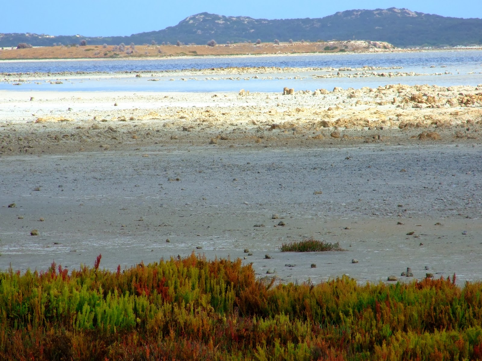
"No Diving," says the sign ... while diving would be a pretty neat trick off Meningie's old jetty -- which ended
long before it reached any water, in 2009! This is Lake Albert, which connects with Lake Alexandrina" We're used to
seeing the lakes from the Milang Side, of course.
Meningie is a popular destination in the region -- a much bigger town than Milang. But we prefer
the peace and quiet of the Milang area.
As you round the lake and approach the Wellington Ferry from the east side, one thing you can count on
is that the weather will be changeable. This shot, and the next, are actually borrowed from our 2011 trip to
Mount Gambier, but they illustrate this point so perfectly, why not borrow them?
Change in the weather (in 2011), waiting for the Wellington Ferry to come back across...
...and here's the exact same place in 2009. Get out of the car, stretch the legs while waiting for the ferry...
A long, long zoom shot of colonial ruins which stand abandoned not far from the river. The region is
full of history drowsing side by side with technology.
There goes the ferry on its way to Wellington. We just missed it. Ten minutes later --
Here it comes, headed for Tailem Bend. Time to get back in the car -- they don't take long to unload.
Halfway across, shooting out of the window -- and already hearing the ruckus! Like Strathalbyn, Wellington
is the home to huge flocks of little corellas ... and when they mill around, they shriek as only wild parrots can.
Little corellas are cousins to sulphur crested cockatoos -- both are common in South Australia.
Invasion of the little corellas! They were everywhere at Wellington on this trip in 2009.
...the trees are full of them, and every ten minutes they'll take off, swirl around in a great cloud,
shriek for the sheer fun of it, and then settle right back down again.
The road back to Stathalbyn takes you through miles and miles of agriculture.
And here we are back at Strathalbyn, where we began --
Ducks graze the parklands, while the Angas River bridge heads across to the bandstand and, beyond, the church.
Wall art ... actually, it's the public rest room beside the park, and -- never miss the chance to
decorate a wall, right?
Detail from the wall art at Strathalbyn ...
-- the work is astonishing, and so beautiful --
-- an unexpected pleasure in the evening light, just before we headed for home.
Evening light o the towers of St. Andrew's church. And now ... time to head home for dinner: we'll
be there in an hour or so.
From the Coorong through to Meningie, all you can do is put your foot down hard, let the Princess Highway zip past at the speed limit, because there's not much there (though it's not as desolate as the area between Milang and Lanhorne Creek, which might as easily be a location on Mars). As you get closer to Lake Albert, on the shore of which Meningie sits, the air becomes, um, shall we say "redolent with the aroma of agriculture." In other words, it's dairy country, with about a thousand times more cows out to pasture than there are people in the region ... your nose will certainly confirm this statistic!

 Meningie itself is a popular holiday spot for folks from far afield; it's quite a large, busy town, though we much prefer the depthless peace and quiet of the Milang-Clayton-Finiss region on the "home side" of Lake Alexandrina. In 2009 the water levels were low (too little rain -- which is becoming way too predictable in South Australia of late; troublingly predictable), and we could only chuckle at the sign stipulating "No Diving!" from a jetty that didn't get anywhere near the lake. Interestingly, "Meningie" is an Australian Aborigine word meaning "mud hole." One imagines the climate used to be a whole lot wetter in the past! (The map to left is a screencap from Google -- see it full sized, if you want to get a grasp on the geography -- it's quite readable.)

Then ... Wellington Ferry again, and the run through to Strathalbyn, where we stopped for a stretch of legs, snack and tea (or coffee, if you prefer; the picnic basket is always well stocked), before we headed home. Wellington had been invaded by little corellas in 2009, very likely the same flocks as gather in Strathalbyn too. They're great to watch, not so great to listen to, since they're LOUD!!

With evening light settling and dinner in mind, we headed straight for home ... which, on the above map, and at the time, was approximated by the "Marion" you see due south of Adelaide. (We've moved since then.)  And "it's a wrap!" That was it for another road trip. Now, where to next?!

Tuesday, January 28, 2014

The Coorong at last ... and the sun shone

The Coorong -- this is where we're headed, from Kingston S.E., and to get there...
... we would drive a looong stretch of the Princess Highway bordered on the inland side by salt flats...
...to the bustling landmark of Salt Creek. It doesn't even show on Google's regional map!
Meals, drinks, bait and tackle -- ah! Bathrooms! And --
The obligatory (educational; useful) information board: welcome to the Coorong. Dave checks out the map.
The lady in the shot is a traveler, not Jade -- Jade was taking the photos.
Opposite the board, t'other side of the road is Salt Creek itself. If only Bool Lagoon had been this wet!
A flock of black swans were feeding, under brooding skies --
A lot of enhancement makes this image bright and colorful, which was far from the truth!
Just so you know where you are...
-- and, a little history before we head off in search of ice cream! 
In the years since this photo was taken, the masked plover population has dwindled to just a couple
of dozen pairs of birds. In a few years more, they won't be seen at all in the South East, which is sad.
On the road from Salt Creek you'll see numerous signs like this. Follow the Loop Road --
-- and find your way to the shore. This is the Coorong ... that's Younghusband Peninsula across the water.
The sun shone again, just at the right moment for us to get good pictures. What looks like snow on the low hills
of Younghusband Peninsula is pristine white sand...
The Coorong at low tide, with a fair sailing breeze cranking up.
Back on the Princess Highway, through miles of saltbush, looking for the next Loop Road sign...
-- and the next discovery of a very different world...

The loudest sound was the wind in the low shrubs, and gulls on the tidal zone. Lovely.
The mid-water islands of the Coorong are protected as pelican nesting sites.
And yes, the weather s changing rapidly ... take the pictures, quick!
We were so lucky to get sunshine and bright conditions, just for a few hours! Look at that sky --
you can see what's coming in, and it's not far away now.
These plants apparently grow in salt water, and they taste -- well, salty enough to be a condiment.
These look like very ancient rocks, and if you look closer, they're often full of fossils -- see below.
Like a shot from The Lost World...
Just one of hundreds of tiny, beautiful coves on the Coorong.
Take a moment to look down. Shells are fossilized in the limestone matrix of the rocks -- everywhere.
Time to be moving again ... we've a long way to go to get home -- and this sign shows you how far
we've come since leaving Kingston S.E. (Aussie road signs read in kilometers, of course.)
From Kingston S.E. you stay on the Princess Highway, point the car at Adelaide and tramp hard on the loud pedal -- it'd be difficult to get lost, because it's the only road. Eventually you'll find your way to Meningie, on the east side of Lake Alexandrina, but it's a looong drive to get there, and along the way you'll be glad to discover Salt Creek -- a roadhouse and a body of water, not a town -- and, yes! The Coorong itself.

This was what we were out to see, and during the morning we'd worried that the weather was changing so rapidly, conditions would be too dark to get good pictures. We were lucky. Just as we left Salt Creek the clouds ripped apart and the sun shone. It wouldn't shine for long, but while it did we visited several of the tiny, secluded bays where the loudest sound was the cry of a gull and the sound of the wind in saltbush.

A lot of boating and fishing goes on in these waters, but the tide was low when we went through. No boats ... just us and the sea and the wind. We could have stayed a lot longer, but we had many miles to travel yet, even to get back to the ferry at Wellington, so we couldn't tarry.

The plan is to go back one day, and stay much longer!

Next: Meningie, Wellington, back in Strathalbyn ... almost home.

Related Posts Plugin for WordPress, Blogger...