

During my forays into the north for conferences at the
University of Sunderland I twice visited Tynemouth – just half an hour on the
bus (the N56 from Roker, as I recall) up the coast, then the passenger ferry
across the Tyne and a walk of a few kilometres around some very picturesque
areas. I’ll come back to this a time or two for the vistas of the estuary by
evening or a look at other attractions, but this time I’d like to touch down on
the historic north headland, a high promontory guarding access to the river. No
wonder the Normans
These photos were taken on my 2010 trip. I had
pressure-related problems with my right ear while flying and spent the entire
trip very ill, I twice visited doctors, once a free clinic in London ,
the other a local surgery in Whitby


November is a very changeable month in the UK , the last
sunny days presaging the coming of snow in some years, at other times it’s
really just rain. In 2010 the sun was shining through the wind was chill, and
the pictures benefited from the light.
After leaving the ferry one walks east on the river bank
through picturesque old sea-village areas, quaint pubs that drip history, past
the memorial to Admiral Collingwood – more about that in another post – until
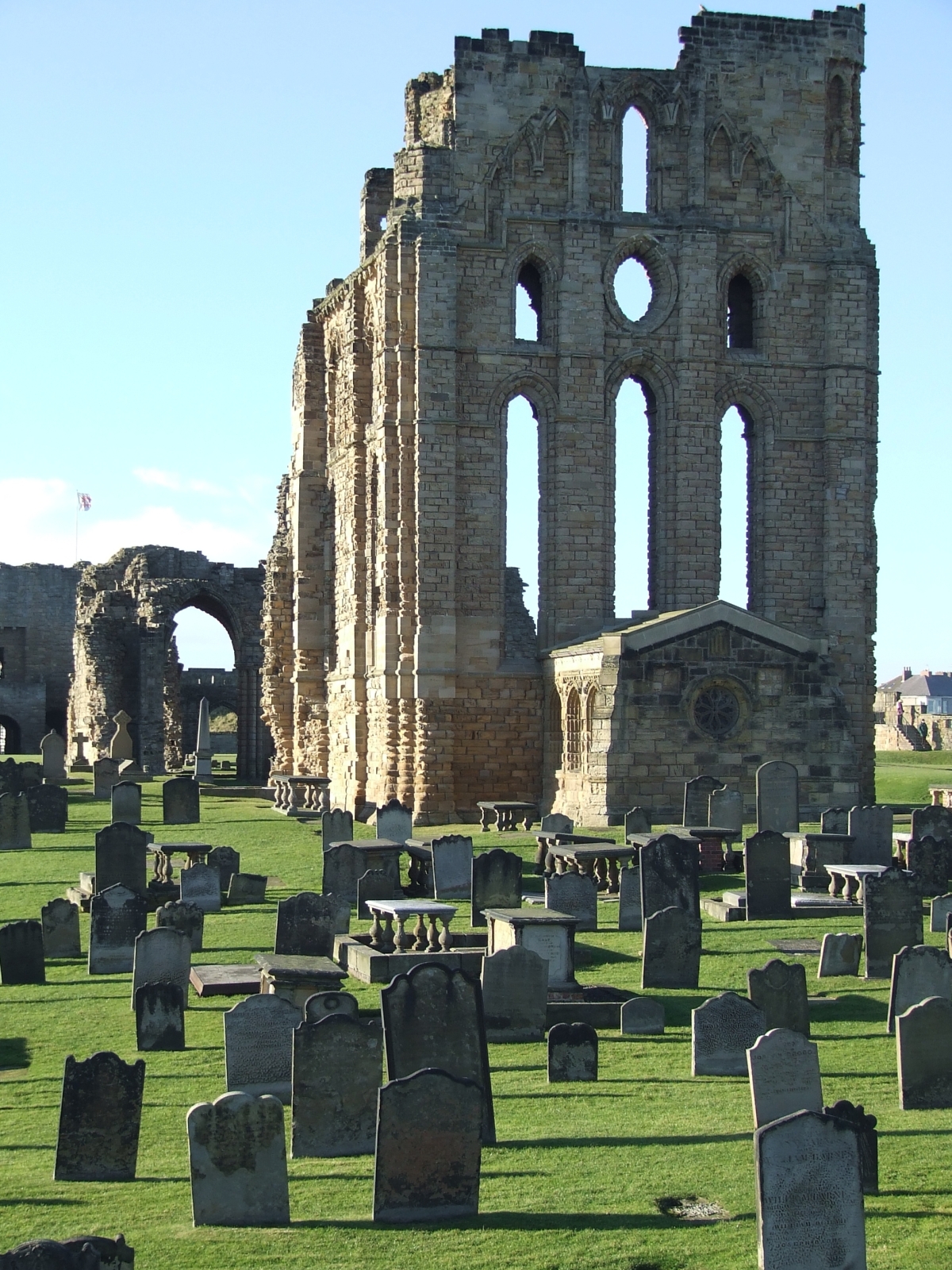
coming to the headland. The ruins are not very impressive from a distance but
up close they have much to offer, and are administered by British Heritage,
whose red and white flag flies over the castles they preserve.

According to both history and legend, three kings are buried
somewhere on that headland, including Malcolm III of Scotland Whitby


The original fortification was a wooden structure built by
Duke William’s invaders (though I find it likely there were earlier structures
on the site), while the extant ruins are of the extensive rebuilding that
occurred in the centuries following. Tynemouth Priory also occupies the
headland, protected by the castle from the landward side, and again not much
survives. It would have suffered during Henry VIII’s crusade of 1539, known
historically as “the dissolution of the monasteries,” when the church was
stripped of much of its wealth, power and influence, and so many magnificent
ecclesiastical buildings fell rapidly into disrepair and eventually ruin. Only
a single internal chamber remains, the “chantry,” complete with stained glass
windows, and this was used in later centuries as a magazine to keep gunpowder
dry.


The military heritage of the headland is everywhere – not
merely the medieval fortress but the guns that guarded the river mouth in much
later times. A canon of 1859svintage is preserved in a firing embrasure on the
north side, but the real link with past turmoil is the battery of light model
1893 naval guns in their concrete and steel emplacements which look out to sea
as a historic exhibit. These guns were manned in the First World War by the
Tynemouth Volunteer Artillery, though the closest the German High Seas Fleet
came to Tynemouth was Hartlepool, about twenty miles south, in the early
morning of December 16th, 1914.


I stood alone on that headland, looking at the autumn
afternoon sea as ferries came and went on their routes to Scandinavia, and
imagined how it must have been for the gunners on that bitter night, seeing the
flashes to the south as Hartlepool took over a
thousand German shells. My late grandmother, aged four, was in that town at the
time, if I remember my family history aright. That night Whitby was also hit, and its famous abbey was
damaged in the process. So in Tynemouth the
gunners must have shivered in their greatcoats and peered into the darkness,
nerves on edge and strung out for a sighting. Not that their already-antiquated
guns would have been of any effect had the German actually shown up, but the
defiant gesture would certainly have been made – and perhaps Tynemouth Castle
and Priory would have also come off worst against the poorly-directed gunnery
of the pre-electronic age.

One other aspect of local lore about the headland must be
mentioned, the ghost of the Viking. Actually a Dane, a warrior named Olaf was
left for dead after a 9th century raid but was cared for by the
monks. In time he took orders and joined them, but many years later during
another raid, he saw his brother killed, and died praying for his lost kin.
Locals know him as the Black Monk, and his spectre, so the story goes, has
haunted that headland for a thousand years, watching the horizon for the
longships to return.


English Heritage has an information office and giftshop in
the castle, and one can buy a day ticket to wander the headland and view
everything from the graveyard of the priory to the monks’ latrine pits, walk
the remaining walls of the fortification and wonder where those kings lie. If
you have a feel for history, a sense of the gulf of human experience that has
flowed by, this is an excellent spot to visit, and you can grab a good meal in
the high street opposite the entry of the castle – try the Turk’s Head pub, I
can vouch for their fish and chips!


Some useful links for further reading:
Mike Adamson


 |
| That's a stone pillar in the mid-ground, not a modern waste bin! |


 |
| Late afternoon light, as I was leaving -- it would be full dark before I was back down the coast in Roker. |


