Showing posts with label kangaroo. Show all posts

Wednesday, November 29, 2023

Kinchina CP, Murray Bridge ... Thunderfoot!


Kinchina is a CP, or Conservation Park, not far from Murray Bridge -- in fact, it's adjacent to the Mobilong facility. Dave and I went there to spot birds (no joy: barely even heard any, and saw just one ... no photos worth sharing). But instead, we saw something we have NEVER seen before. And although I was thrilled and privileged to see this incredible animal, I actually hope not to see another like him. I'll call him Thunderfoot, because --


When he took a STEP -- not hopping, just stepping forward -- the impact of those immense feet sounded like a horse cantering over soft ground. Thudd!!!! 

We heard him before we saw him. We knew something was out there. I wondered if there were some big horses loose in the park -- a whole bunch of deer jumping at the same time could have made a similar thudddd sound. Then Dave spotted what we thought (ha!) was the proverbial Really Big Roo. I said words along the lines or "Wow, look at the size of him!" I popped a couple of frames ... then noticed the body morphology. It was the female. The doe --

And then Dave spotted the male. The one who made that heavy, dense, soft thuddd every time he took a step. When you weigh about 200 kilos, this is what it's going to sound like -- and this weight estimation is based on observation and cold, hard logic. A horse easily weighs more, but it sounds comparatively loud because all that weight is falling on a small area, the hoof: a horse walks on its middle toe, right? Now, consider an animal which is not called a macropod, or big-foot, for no reason. His feet are immense. To hear that same "shire horse cantering" type of thuddd sound, you'll need an utterly enormous weight spread out over that huge foot.

The size of him ... 

Those are trees, not shrubs, around him. That's a boulder, not a little rock, just left of centre of this frame. Now, look at the foliage on the foreground tree: mark the scale of it ... but this animal is standing at least eight meters, probably closer to ten, behind that foliage!!

At left here, Dave is standing beside one of the mock-up ancestral animals at the Womambi Fossil Centre, back in 2009. It's one of the extinct tree-browsing kangaroos. (Imagine the proverbial Really Big Roo with the face of a koala, which evolution designed to reach up and browse tree foliage.) The critter at Kinchina, whom we're calling Thunderfoot, is waaaay bigger than this extinct browser. 

Think of the biggest male roo you've ever seen at Belair NP, or Onkaparinga Gorge, or wherever, and -- literally double it. 

It was like looking at a shire horse, and when he moved, that's what it sounded like, back among the trees. 

I've never before felt that frisson of "Oh, oh ..." when coming across a roo in the wild. Never saw one that concerned me, much less made the breath shorten and the hair rise on the back of the neck.

Very carefully, I doubled back around to get a line-of-sight on him without trees in the foreground...


There's nothing for perspective in that shot, but we can tell you this much: if he were to stand up straight, his head would be around nine feet off the ground. Up on those toes? Standing in your living room, his head would be right through the ceiling. His shoulders ... it was like looking at a bull --

A bull that has seen you, is looking right at you, and you're in his territory, and his female is only twenty meters away. For all we knew, there could have been a joey (his baby) in the area, which makes any wild animal protective. He was intent on me, likely for good reason. No way in any world would this animal be leery of a puny little human, but where his joey is concerned...

I popped a couple of quick frames, then very carefully turned around. To be safe, you walk at right-angles to a big, wild roo: you don't make eye contact, and you do not move like you're slinking or sneaking. Slinky walking, eye contact and walking directly toward them emulates the stalking characteristics of the only predator evolution ever threw at animals this big. There haven't been wild dingoes in this part of South Australia for many years -- I don't even know if they're even still wild up in the state's north. But the programming of evolution isn't going to change, not in another million years.

So we walked on, and heard Thunderfoot and his enormous missus boom off into the bushland. It was thrilling, a little bit scary -- like almost but not quite blundering into a grizzly bear in bush Alaska. I wouldn't trade the experience for anything, yet at the same time, I hope not to repeat it! I honestly did not know that roos grew this big  -- and yes, I know exactly what the official documentation says! But I also know what Dave and I experienced. We're savvy people, and entirely used to Clydesdale horses, wild bull moose in Kincaid Park, camels ... those taxidermed bears in the big glass cases at Anchorage Airport! We know what we saw. 

And I won't be diving through the bush with quite the abandon that I used to! Radar on, wits about you, and make enough noise that wildlife can hear you coming! Because it's bigger that you are. A lot bigger. And it has eight-inch talons! It's very fortunate indeed that roos, even humongous ones, are such peaceable herbivores: they absolutely will not attack you ... unless you give them a justifiable reason, like startling them by running right into them, which would make any animal come up swinging.

 So -- don't given them a reason!


Wednesday, March 4, 2020

Wetlands rule at Onkaparinga's Perrybend Point


You can almost, almost forget you're still in the metropolitan area at the Onkaparinga wetlands -- Perrybend Point, where the river meanders westward to meet St. Vincent's Gulf. It's a fantastic place to put a kayak in the water, or a fishing line, or to dig for clams. If you're a "birder," it's all about pelicans, ibis, egrets, cormorants, herons, spoonbills, and many more. If you're into hiking, it's a fantastic place to spend a morning -- or a whole day. And every season puts a different place onto this wetlands park.

What you can so easily forget is that the suburbs actually surround you here ... and it's quite the reminder when a city- or southbound train crosses the railway bridge, which is a recent construction (and built with great care, so that it straddles the wetlands without in any way damaging them)...


Most or all of the trails are open to cyclists as well as hikers, and in any season it's a great place for photographers. Dave and I visited just a few days ago (when most of these shots were captured), and light levels were low; the place looked a little subdued with unseasonal "meh" weather. So I though, oh, I won't be taking many photos today. In fact, I took about 125 -- the equivalent of five rolls of film, way back when!

A healthy mob or roos lives in the native scrub and reed beds, but you'll usually need to be there at dawn or dusk to see them. I've never managed to do that (yet), but countless "roo beds" are everywhere ... great flat places where the big roos flatten the tall grass and reeds.

Just occasionally, if your eyes are very sharp, you'll pick out a cute little face -- these guys are experts at camouflage. But if you don't see roos, keep an eye open for ibis in the reed beds, and many bird species in the surrounding woodland...


In any season, the park is a fantastic place for photographers with an interest in wildflowers. Almost every season brings its own native flowers; only high summer (December to February) is so parched and hot that you might not see much. The Aussie native scrub dries out and just waits, like animals and humans, till the rains come. But by March --


One of the highlights for hikers has to be the boardwalk, which takes you right out through the reed beds. You might see ibis, pelicans, or flocks of welcome swallows, diving for bugs all around you. Three benches are set on the boardwalk, making it a nice place to stop for coffee --

You'll need to take your own coffee, of course: the only facilities at Perrybend Point are a couple of good car parks, a public bathroom at the main one on River Road, where the parking area also features picnic tables and pavilion ... and a live-or-frozen bait dispenser, for the fisher-persons, who abound on the riverbank.


There's a great deal more to the Onkaparinga wetlands than this, but I can only cover so much in one post. I'll come back for another, later, and link the two together. For the moment, I'll leave a hint of what winter can bring to this region, when the fields and slopes turn to gold with soursobs (think Aussie buttercups ... but they're not popular with local gardeners and farmers), and waterfowl come in, in profusion, to breed, utterly ignoring the railway bridge...


Thursday, April 4, 2019

Halls Gap ... "Under the Mountain," literally!


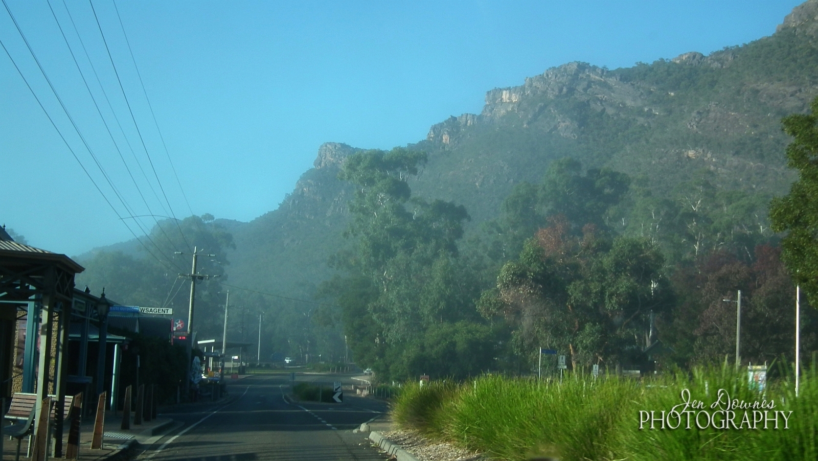
The Village of Halls Gap lies in a pass in the Grampians, quite literally "under the mountain," and often invisible in the morning mist. Here, we see it from Boroka Lookout, in late March 2019...


Driving into the village, you're tremendously aware of being in a mountain pass. The walls rise like ramparts, almost at the bottom of people's back gardens...


From the street -- where you'll find everything you could possibly need, from a newsagent to a supermarket, by way of cafes and ice cream parlor -- just look up under those vines:


The view from the roadside is spectacular!


There's more to Halls Gap than, at first, you assume. Quiet streets angle back from Grampians Road, which is the main thoroughfare, into woodland that's abundant in wildlife, right in the village.


On misty mornings (of which there will be many), Halls Gap drowses like Brigadoon until the sun burns off the fog ...


Up on Boroka Lookout here, it's already sunny (if not quite warm! You're 616 meters high), but if you look off to the left side, you can see the mist that still fills the gap --


...yes, Halls Gap is down there. Did I say Brigadoon?! Magical.

Having arrived in the village, you have about a hundred choices of where to stay. This was ours:


We booked a log cabin at the aptly named Halls Gap Log Cabins ... one word: fantastic! First, there are kangaroos, wallabies, emus, bilbies, in your backyard --


And perhaps just as importantly, the cabins are absolutely luxurious, with a combustion heater, TV/DVD, full size fridge, queen size bed, spa bath ... the works:


You might be in a village in the mountains, but you're certainly not roughing it! (Though there's plenty of that, if you want it: caravanning and camping are very well catered to.)

Now, what about dining out? We did brunch at Harvest, and dinner at Darcy's, which is the restaurant attached to the Comfort Inn...


The food is excellent, and in the evening, long after the sun is down, the grounds around Darcy's, back and front of the Comfort Inn, are thronged with grazing wallabies and kangaroos:


Check out the roo getting a drink at the fountain there! Too cute.

The cultural heart of Halls Gap is Brambuk, where 'Grampians' becomes 'Gariwerd,' and the country's original owners' voice speaks clearly:


We need to set aside a whole afternoon for Brambuk. There's far too much to see and do than you could manage by strolling through. Also, a very nice cafe and the usual gift shop.

On the way out of town...


Lake Bellfield is a man-made lake ... the reservoir serving Halls Gap and the surrounding area. Completed in 1966, just 18 years before Grampians National Park was declared. In Victoria, swimming and sailing are allowed on many of the reservoirs ... wish we did this in SA!

Leaving Halls Gap --


-- the only question is, where are we going today? Hang a right, head for the national park, and keep the cameras handy, because every time you come around a bend in the road, something spectacular happens...


Sunday, March 31, 2019

Destination: Grampians!


Mountains. For years, I've been wanting to see mountains (yes, "mountains, Gandalf!") again, because we just don't have them in South Australia. The last time I saw a mountain with my own eyeballs was almost twenty years ago (Alaska, where else?) so ...

The Grampians lie in the far, far west of Victoria, which to us is a five hour drive east. To give you some context here --


Climb into a decent car. Start where it says ADELAIDE and end where you see that orange balloon, which is pointing at a gorgeous little town called Halls Gap. That's where you're going, with a booking at the fantastic Halls Gap Log Cabins.

The scale of the above map doesn't matter much, because how fast you can do the journey depends on so many factors (differing state speed limits, road construction, how fast you feel comfortable driving, what your car will do without protest ... the number of humongous trucks on the road, how often you need to stop and rest, if you're going cafe to cafe ... whatever). 'Nuff said if I tell you, it's five and a half hours if you don't stop at all, and closer to seven and a half in reality, because if you don't stop, you'll probably drive right in front of one of the aforementioned gigantic trucks.

But the drive can be fun in its own way, and I'll tell the story of that in another post. For now, this is a look at the Grampians themselves ...


Lake Wartook

One of numerous waterfalls at Mackenzie Falls
And again, let me give you a bit of context here:

The whole Grampians area was created a national part only as recently as 1984, and it's a mercy that this was done because agriculture, logging, residential building ... it's all impacted enormously. It was only a matter of time before someone found something to mine there, and ...! Thank heavens, the national park status protects this, ostensibly forever.

The region itself is ancient. I'll save you zipping all over the Internet and paste in this segment direct from the Victorian Tourism site:

Aboriginal people have had an association with the Grampians for more than 30,000 years. Traditionally known as Gariwerd, the land is at the center of creation stories for many of the Aboriginal communities in south-western Victoria. Discoveries of Indigenous Australian artifacts in the region include ancient oven mounds, scatterings of stone left over from tool making, and ancient rock art sites.

Six seasons

The traditional owners of Gariwerd recognize six distinct weather periods in the seasonal cycle, which relate to climactic as well as environmental events such as plant flowering, fruiting and the behavioural patterns of local wildlife. For millennia, the Jardwadjali and Djab Wurrung people have been linked to this seasonal cycle, which includes Gwangal Moronn (the season of the honey bee), Chinnup (the season of cockatoos) and Petyan (the season of butterflies). 


The first thing someone like myself says, upon getting into the mountains is, "OMG, it's like Scotland!" (Okay, that's the second thing. The first thing is, "My God, they're big, they're huge, I had no idea they were this enormous, they don't look so vast from a distance..."). In fact, Gariwerd was promptly renamed as the Grampians by oncoming Scotsman Sir Thomas Mitchell, for the most obvious of reasons! This, from Wikipedia:

Named Gariwerd by one of the local Australian Aboriginal languages, either the Jardwadjali or Djab Wurrung language, the ranges were given their European name in 1836 by Surveyor General of New South Wales Sir Thomas Mitchell after the Grampian Mountains in his native Scotland. After a two-year consultation process, the park was renamed Grampians (Gariwerd) National Park in 1991, however this controversial formality was reversed after a change of state government in 1992. The Geographic Place Names Act, 1998 (Vic) reinstated dual naming for geographical features, and this has been subsequently adopted in the park based on Jardwadjali and Djab Wurrung names for rock art sites and landscape features with the National Heritage List referring to "Grampians National Park (Gariwerd)".

In fact, tourist is the area's One Big Thing at this moment. The town of Halls Gap is quite literally one enormous hotel sprawling out through the "gap" itself ... which is a pass through the flat bottom of a narrow valley through the mountains, frequently lost under morning mist. From Boroka Lookout, at an altitude of 616m right above, you can look down on the town, see it appear out of the mist rather like Brigadoon, as the run rises...

Boroka Lookout, looking toward Lake Bellfield ... Halls Gap is down below, right in the mountain pass...

Boroka Lookout on a misty morning. Halls Gap appears out of the mist like Brigadoon...

The river of mist has completely covered Halls Gap. Down below, it's silvery with fog in the town...

Dave captured this shot of me photographing the dawn at Boroka Lookout. Neat!
I can say without hesitation, the Grampians is one of the most glorious places on this planet, on a par with the Alaska Range, the wilds of Canada, you name it. And the wonderful thing about it is, we don't have to fly across the world. A long drive, and we arrive on the same day we set out, without even seeing an airport from a distance (nudge, wink ... anyone else out there detest airports, though they love flying??) or even boarding a train.

The Grampians offer absolutely everything. Want a top-notch hotel or a cozy log cabin? Done. Fancy restaurant? No problem. Rock climbing? Birding? Blue lakes? Wildlife? Hiking? Photography, art? Here we go --

Lake Wartook, seen from the other side of the carpark at Reed Lookout

The Grampians, from a Wartook Valley roadside

Dave sits on that famous rocky ledge at Boroka Lookout, in the dawn light. 616 empty meters under your feet there...

A wedge tailed eagle has discovered dinner in a paddock in Victoria Valley

Wallabies, kangaroos, emus, echidnas and bilbies abound right in the heart of Halls Gap itself
Or if culture is your thing, try the Brambuck Cultural Centre --


-- but be sure to set aside a whole day for this. If you try to stroll through in an hour, you'll miss so much. We just didn't have the time to do this properly, so ... next time.

Or, if the more recent history of the area is on your mind, a lot of info is given in situ, on the info boards at the various lookouts. Such as this, at Mount William:


Admittedly, we ran through the Grampians. We had three days, all up, including the drive out and back. So we did ... one fancy restaurant, one cafe, one waterfall, two lakes, four or five lookouts, one camp ground, two dawns, and an enormous amount of driving.

We covered 1,500kms in all, and I can honestly say, we saw Gariwerd from the road...

Stand in the street in Halls Gap and look up. This is how you'll see the Grampians!

A roadside shot, in Victoria Valley

Amazing landscapes, every time you turn around another bend in the road


Full marks to the Victorian government for the road system that threads through and around the Grampians. The roads are in fantastic repair, and they're very well signed. The only thing South Aussies may find somewhat perplexing is that many of the roads are marked up as "driving hazards," or "dangerous conditions," and so forth. In fact, by comparison with our Adelaide Hills (Norton Summit, anyone?!) the Grampians are an easy, easy drive. They're not dangerous at all at this time of year. I do wonder what it'd be like to drive them in winter. It does snow there. Mount William is tall enough ... this, from the Halls Gap Lakeside webpage:

Having spent my childhood in Holland I never realized how many Australians have never experienced snow! This might be your chance, without spending an absolute fortune visiting the snow fields! Although snowfall in the valley itself is rare, Mt William (the highest point in the Grampians at 1167 meters) gets covered in snow nearly every winter, it’s great for making a snowman. The Grampians turns into a winter wonderland, beyond beauty!

Oh, yes, I'm tempted. Very tempted. We went there (for the first time!) and the end of the first month of autumn, or fall, if you prefer, and it was already very chilly in the mornings, though you were glad to get out of the sweaters and scarves by ten o'clock...

Lake Bellfield, on the outskirts of Halls Gap

A misty dawn, from Boroka Lookout


Halls Gap is lost in the mist, 616m below...
In other posts, I'll share the drive to get there and back, which is an adventure in itself! Mother Nature had one special gift in store: the most incredible sunset on the river at Tailem Bend. Soon!
Related Posts Plugin for WordPress, Blogger...