 |
Carrickalinga is a comparatively tiny community that's growing rapidly, since developers arrived.
It sits on one of the most beautiful bays on the Fleurieu Peninsula, on the Gulf St. Vincent.
The area was a haven for wild birds, but human impact -- well... |
 |
Save the hooded plover ... three years ago, only 75 birds
were left on the Fleurieu. at time of this writing in 2014,
I believe it's a lot less. Which is sad. |
 |
| Leaving Carrickalinga, you hang a right and head south into a very different landscape... |
 |
| Cliffs typify the coastline from Rapid Bay to Cape Jervis, and -- |
 |
| The skyline is punctuated by wind farms, with windmills turning slowly in the endless wind off the Southern Ocean. |
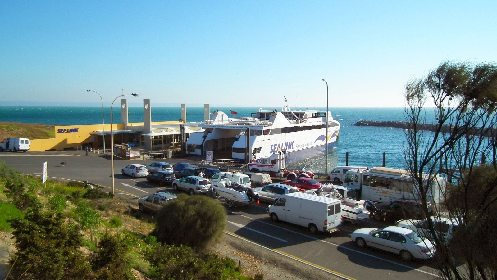 |
| Cape Jervis at last! The terminal for the Sealink ferry between mainland South Australia and Kangaroo Island. |
 |
| All aboard! Drive on and park, next stop, Penneshaw on the northeast coast of the island. |
 |
The Sealink is the only way to get vehicles to Kangaroo Island -- hence the traffic -- but you can also fly.
Rex Airlines offers the 30-minute flight. Now, that would be fun! |
 |
| Adjacent to the Sealink ferry terminal is the Cape Jervis small boat harbor, from which fishing charters embark. |
 |
The hike to the top of the bluff offers a fantastic view. The dark ridge line down on the horizon isn't cloud...
in fact, that is Kangaroo Island; it's actually that close -- |
 |
| And speaking of fishing charters --! This one is headed home as afternoon winds down toward evening. |
 |
Leaving Cape Jervis, we were headed for Normanville, where we were staying overnight. The country is very lovely.
Shots like this are taken through the windscreen, at about 60mph ... the smudges in the sky are on the
windscreen, and I decided not to paint them out, because they're actually part of the trip! |
 |
| Afternoon is heading rapidly into evening: sunset light on the hills at Rapid Bay. |
 |
| Evening light colors and mists the cliffs stretching south, back toward Cape Jervis... |
 |
Look at that light! Couldn't resist stopping at this parking lot for photos. The view of the cliffs, above, is
just about right behind you, as you look at these Norfolk Island Pine trees. |
 |
| Normanville at last: dinner on our minds, while we wait for sunset... |
 |
| Normanville Jetty by evening light. Notice the clouds on the horizon! Is the weather changing?! |
 |
| Normanville beach, looking south towards those cliffs... |
 |
| Sunset over the Gulf St. Vincent ... stand by with the cameras! |
 |
| Sunset photography is one of life's pleasures, but it can also be dramatic -- |
 |
Like looking into the heart of a furnace. This is photographed at something like a 500mm zoom; you can
get closer, but the "structure" of the picture is perfect right here. |
 |
Right behind you as the sun sets, the full moon is rising. Tonight was the moon's closest point to Earth
in many years, so it looked huge -- this isn't a special effect, no Photoshop involved here. |
 |
| Moonrise over Normanville, just as it happened ... no special effects. Lovely! |
 |
Right on sunset, anglers were setting fishing lines on the beach, and one or two were actually launching
boats, a sure sign that some kind of fish is "running" in the twilight. This boat is headed home --
eight or nine pictures above, you saw it still in the water, waiting to be trailered. |
 |
| Last of the sunset, over Normanville jetty... |
 |
| Next morning: little corellas begin to wake in the early morning light. Loudly. |
 |
We took a walk after breakfast and before checking out. Normanville has some huge specimens of the
Moreton Bay Fig -- Ficus macrophylla. Says Wikipedia, it's "a large evergreen banyan tree of the Moraceae family that is a native of most of the eastern coast of Australia, from the Atherton Tableland (17° S) in the north to the Illawarra (34° S) in New South Wales, and Lord Howe Island. Its common name is derived from Moreton Bay in Queensland, Australia." There -- now you know. |
 |
| River Parananacooka ... say this three times, fast, after a couple of gin and tonics. Urp. |
 |
| Leonard's Mill, at the Deep Creek exit -- restaurant, cafe, hotel. Must do this sometime... |
 |
Notice the sky over Leonard's Mill? Lots of enhancement makes the image bright and colorful,
but yes, we're losing the weather rapidly. |
 |
Smuggler's cove! Rapid Bay, and look at those caves at the waterline! In the distance, that's Normanville
you're seeing; we left there about an hour ago. |
 |
The feature for which Rapid Bay is best known is its enormous jetty, which is a destination for scuba divers.
Lots of marine life around here: as the ancient jetty rots away, it's creating a great habitat for critters. |
 |
Did I say Smuggler's Cove? There's the cave to smuggle from! Now, smuggle what...? "Laces for a lady,
letters for a spy." Thank you, Mr. Kipling. |
 |
From Second Valley you could see the extent to which the weather really was changing -- but it offered
an opportunity to capture some superb seascapes. |
 |
Leaving Rapid Bay and heading back inland, past a refurbished colonial era barn ... the stonework is
about 150 years old, the roof is brand new. Gotta like this. |
 |
Delamere is a region, not a town. It's on the map, but when you get there it's a fork in the road with a
little store selling everything from gasoline to ice cream... |
 |
| About a mile west is the Second Valley Forest Reserve. Pocket-size sustainable timber industry... |
 |
And here's what the conditions were really like! This is noon. No enhancement on this one.
Now, where did we put those umbrellas and rain ponchos --? In fact, we were lucky:
we managed to skip around the skirts of the rain, never actually got wet. |
 |
Just so you know where you are: outside Delamere and 48ks from Victor Harbour ...
Beef cattle on the range. In this part of the world, all beef and dairy are "grass fed..." |
 |
| The dairy herd in the paddock, against the backdrop of a timber plantation. Must be near Delamere, right? |
With the weather changing visibly, we meandered back and forth across the Fleurieu Peninsula, touching down on places we hadn't seen in years, and just one or two we'd never seen at all. We were booked into accommodations in Normanville ... and we probably won't do this again, because it was
way too noisy. At the height of the vacation season (weather notwithstanding!) it seemed every man and his uncle were on holiday, and staying in the same place as ourselves. It either finally quietened down by 2:00am, or else Jade was so tired by that point, she went to sleep despite the ruckus. However, there's quieter places than Normanville, by far, and one of the best things about the Fleurieu Peninsula is that nowhere is far from anywhere, so your range of choice is close to limitless.
The changeable weather did offer an opportunity to get some
marvelous pictures -- the kind of images you don't get in brilliant, blue-sky weather. It's also great to go so far south, the landscape changes utterly.
Next on this trip: Goolwa, Hindmarsh Island and Victor Harbor.


