Showing posts with label boats. Show all posts

Wednesday, March 4, 2020

Wetlands rule at Onkaparinga's Perrybend Point


You can almost, almost forget you're still in the metropolitan area at the Onkaparinga wetlands -- Perrybend Point, where the river meanders westward to meet St. Vincent's Gulf. It's a fantastic place to put a kayak in the water, or a fishing line, or to dig for clams. If you're a "birder," it's all about pelicans, ibis, egrets, cormorants, herons, spoonbills, and many more. If you're into hiking, it's a fantastic place to spend a morning -- or a whole day. And every season puts a different place onto this wetlands park.

What you can so easily forget is that the suburbs actually surround you here ... and it's quite the reminder when a city- or southbound train crosses the railway bridge, which is a recent construction (and built with great care, so that it straddles the wetlands without in any way damaging them)...


Most or all of the trails are open to cyclists as well as hikers, and in any season it's a great place for photographers. Dave and I visited just a few days ago (when most of these shots were captured), and light levels were low; the place looked a little subdued with unseasonal "meh" weather. So I though, oh, I won't be taking many photos today. In fact, I took about 125 -- the equivalent of five rolls of film, way back when!

A healthy mob or roos lives in the native scrub and reed beds, but you'll usually need to be there at dawn or dusk to see them. I've never managed to do that (yet), but countless "roo beds" are everywhere ... great flat places where the big roos flatten the tall grass and reeds.

Just occasionally, if your eyes are very sharp, you'll pick out a cute little face -- these guys are experts at camouflage. But if you don't see roos, keep an eye open for ibis in the reed beds, and many bird species in the surrounding woodland...


In any season, the park is a fantastic place for photographers with an interest in wildflowers. Almost every season brings its own native flowers; only high summer (December to February) is so parched and hot that you might not see much. The Aussie native scrub dries out and just waits, like animals and humans, till the rains come. But by March --


One of the highlights for hikers has to be the boardwalk, which takes you right out through the reed beds. You might see ibis, pelicans, or flocks of welcome swallows, diving for bugs all around you. Three benches are set on the boardwalk, making it a nice place to stop for coffee --

You'll need to take your own coffee, of course: the only facilities at Perrybend Point are a couple of good car parks, a public bathroom at the main one on River Road, where the parking area also features picnic tables and pavilion ... and a live-or-frozen bait dispenser, for the fisher-persons, who abound on the riverbank.


There's a great deal more to the Onkaparinga wetlands than this, but I can only cover so much in one post. I'll come back for another, later, and link the two together. For the moment, I'll leave a hint of what winter can bring to this region, when the fields and slopes turn to gold with soursobs (think Aussie buttercups ... but they're not popular with local gardeners and farmers), and waterfowl come in, in profusion, to breed, utterly ignoring the railway bridge...


Sunday, January 13, 2019

Memories of AK sailing: Aialik Bay, 1987

It's an enormous pleasure to add to -- expand, amplify -- the "Alaska Memories" aspect of this meandering travel blog with a guest post: Anna Walker remembers sailing on SV Ghostrider in the 1980s and 90s, a golden age in so many ways.

Many photos were captured in the days long before digital photography -- oh, for the joys of being able to go back to those times with today's technology! Since that isn't possible, it was my great pleasure to through the "Aialik Bay, 1987" pictures, rescue what I thought were the best, and digitally enhance them to bring the most out of them.

Dave and I were not there on this trip, but I did go out on Ghostrider, and stay aboard several times ... those memories are among my most cherished, and one day I'll get Dave going, have him tell his stories. (He has some astonishing and even hair-raising stories to tell of sailing the Gulf of Alaska in all weathers. I'm sure we can track down some photos to accompany his stories ... the most I can offer is the skill to digitally remaster them!) But for the moment, it's over to Anna for a very beautiful guest post:


Ghostrider in our favorite anchorage in Aialik Bay.   First of all, it's not on the charts.  It's a tiny little teacup, barely an indentation on the charts.  It's protected in all weather events, far enough into the bay that wave action can't impact it.  To reach it you either know about it by local knowledge or you follow the shoreline carefully, dodge a couple large ledges of rocks, requiring you to dogleg around the ledges and you're there.  The cove is only large enough for two boats, requiring you to run a line to shore to tie the stern of Ghostrider to a very large tree or boulder to hold her in place.  You drop your anchor in about 50 feet of water, back down on the anchor to lock it into the sandy bottom, then run a line to shore with a dingy.  The surrounding land is granite boulders but millions of years of erosion has created a sand and gravel bottom for an anchor to bite into.  Once settled into her anchorage Ghostrider rode out several large storms with barely a motion.  We also watched cruise ships sail serenely past, never knowing we were hiding there.


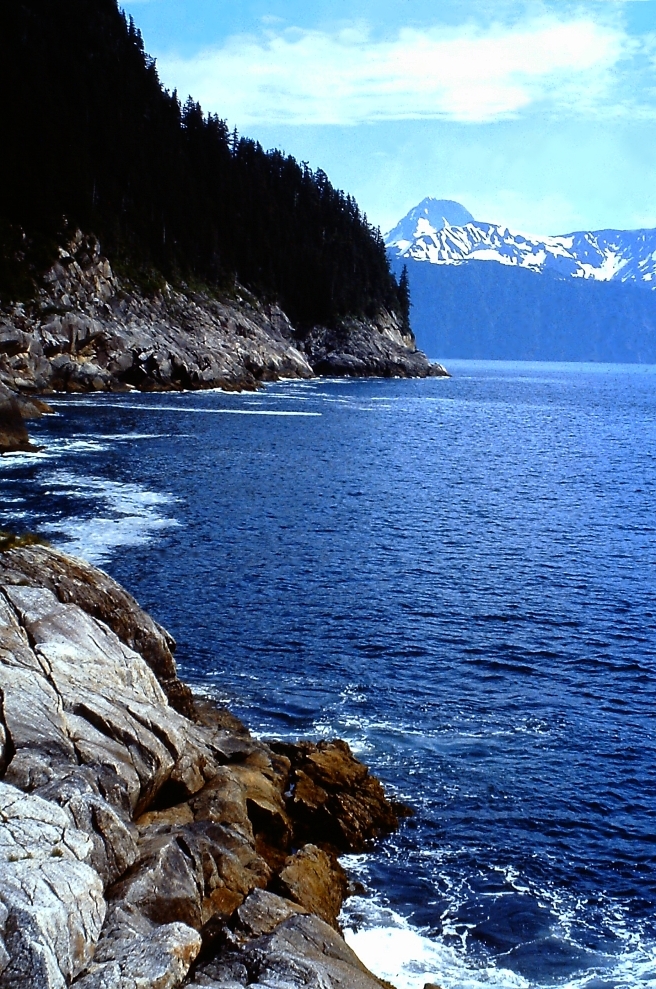
One of the many shorelines leading into Aialik Bay.  The Pacific Ocean pounds into the shore, throwing huge spray and creating thunderous booms.  It's beautiful and deadly all at once.  On a calm day hiking this shoreline reveals rain pools of water in the boulders, warmed by the sun, just needing a towel and some soap for a bath.  Sitting in one of those carved rock pools you can watch the ocean for miles, with no sign of human activity.


Have to set the scene.  Early morning dawn, around 5 a.m.  Sun has been up for hours (it is AK summer after all) but the fog is thick, almost no visibility in our little teacup anchorage in Aialik Bay.  Water is still, perfect mirror reflections.  Sitting on the cabin roof, coffee in hand, camera at my side.  Perfect time for an otter to float by, or a whale.
  
Through the fog you can hear the calls of eagles and other birds, the occasional slap of wings against the water and even though you can't see them you know that eagles are fishing nearby.
  
The sun begins to burn through the fog, a white orb appearing in the silver white clouds.  The water begins to appear, the fog lifting showing the green reflecting sea.

Sliding out of the fog a bald eagle appears, wings almost touching the water as it glides, looking for a fish just barely under the surface.  It reaches for its prey, talons extended and misses.  With a single beat of silent wings it rises from the water, disappearing into the fog.  In a few moment it appears again, ready for another attempt.

Memories of AK sailing.


Ghostrider carries about 100 gallons of freshwater and on a long voyage it's necessary to supplement it with water from a stream.  The trick is to find water that 1), is easy to get to, 2) is not contaminated with either salt or by animals and 3) easy to haul back.  Water is heavy, so you have to take that into account in your search.  If you find a good source but you can't carry full jugs back to the dingy you've wasted your time.  The water retrieved is used for bathing, not cooking or drinking, just in case there is some type of contamination.  Fetching enough water for showers for everyone on board can take several hours.  And sometimes it's quite the adventure.  Launch the dingy, go to shore, find a stream outlet, then  take your container for water.  Sometimes it's a waterfall, and you can actually row up to the pool the waterfall makes, sink your containers, fill them, and come back.  Other times you hike up a stream bed to a small pond.  If nothing else it makes you appreciate running water and a tap that you just turn.


Jen, amazing what memories come back.  In all the years we roamed Aialik Bay we only shared that anchorage with 3 other boats.  Nobody believed it was there until we showed them photos and our chart with all the notes on it on where and how to get there.

Sunday, June 5, 2016

Brighton and Seacliff: cafe culture and yacht races on the metropolitan beaches

Brighton, South Australia -- a fantastic place to spend a sunny winter's afternoon in June...
Brighton is all about cafe culture: gourmet coffee and good food, along Jetty Road --
Jetty Road, Brighton, in the summer ... cafes galore to your left as you head to the beach. See that arch up ahead...?
The Arch of Remembrance is the "gateway" to Brighton's jetty --
The Brighton Jetty is easy to pick out of any assortment of jetty pictures...
...it's the structures ON the Jetty that make it so easy to recognize. Like --
The Aeolian Harp, or "wind harp." Stand under it, when the breeze blows!
The view south from the Brighton Jetty looking towards Seacliff. We're going there next.
Time to head back for dry land ... and coffee!
Cafe culture on a lavish scale. It's your choice of a dozen different places to eat. Then --
Turn left from the end of Jetty Road ... Seacliff is a whole whopping kilometer away!
Seacliff is all about holiday homes and mansions, right above the rocky reef.
Seacliff on a summer day -- not much difference visually between summer and a sunny day in winter.
The big difference is the temperature. Winter's not really cold, but summer...!
A close-up look at the reef itself. Paradise for beachcombers. See the houses at left, there? Well --
--here they are in summer. Could be the Mediterranean, or the Adriatic. 
Low tide on Seacliff Reef ... tidepools full of tiny crabs.
Seacliff Beach looking back towards Brighton, where we were ten minutes ago.
On top of the cliff at Seacliff is a lovely little gazebo with incomparable views, like...
The view from the top, at Seacliff, over the Surf Life Saving Club roof, to those mansions. And --
The famous "Seacliff ZigZag," which is a zig-zag ramp connecting clifftop with beach and yacht club.
Seacliff Reef is a rich fishing ground for local professional fishermen and amateurs alike...
Also the perfect place to put a 'trailer sailer' in the water for an afternoon. Or --
Water skiing? Sure. You also see paragliders, kite flyers, beach cricket -- the works.But if you want boat races...
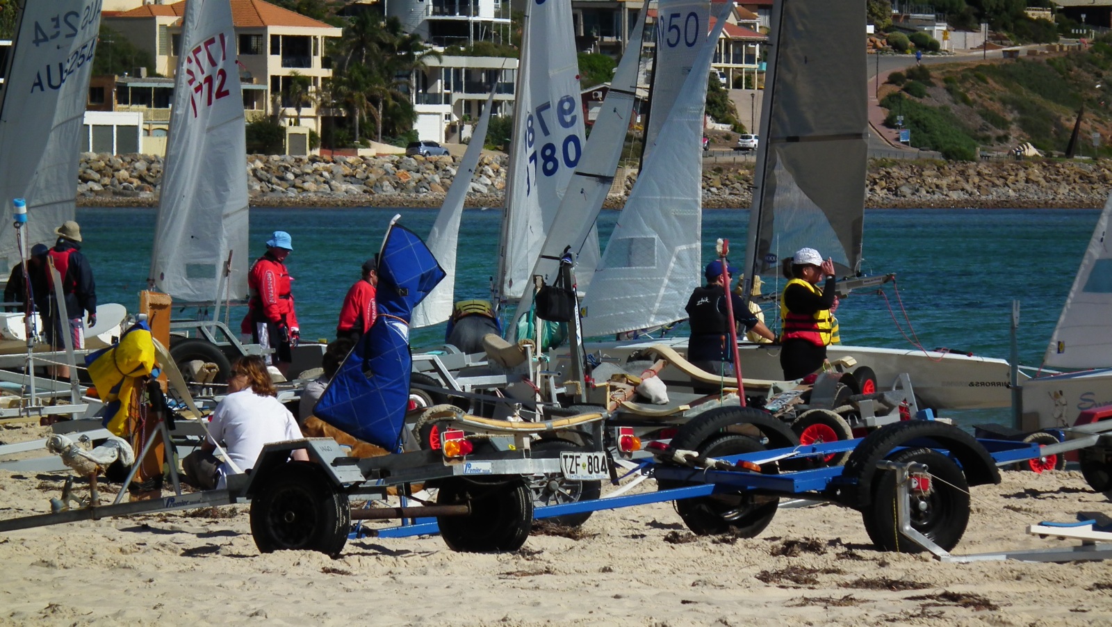
Setting up for a boat race at Seacliff Yacht Club.
The tractor helps launch boats at Seacliff.
Yachts ranked on the Seacliff beach, ready to race...


And they're racing! 

Anyone for coffee? A kilometer north, and you'e back to Brighton's world of cafes on Jetty Road!
Down under, June is the middle of winter, and when the sun shines, people make the most of it. Winter has to happen sooner or later ... it's gotta rain, or we'd be living in the Sahara, and we don't want that! In fact, we're always glad to see a drop of rain, especially on the rare occasions when it comes in summer; but in winter, when we see a blue sky day, we grab the opportunity.

Today we headed 'in' rather than 'out' ... of town, that is. Usually, we make tracks for the hills and valleys -- national parks and woodland. But with this sky, we headed into the southern suburbs with the idea of doing a "beach crawl," from Brighton to Seacliff, then on to Marino and Hallett Cove. Here's the first of two posts: Brighton and Seacliff. Well go to Marino and Hallett Cove in the next post.

Most of Adelaide, South Australia, has access to what we call the 'metropolitan beaches.' It's just what it sounds like: the beach where the city ends on the west side. Look at a Google satellite image of the Adelaide area --

We're one loooong coastline, with the city sprawling north-to-south. The beaches begin at Port Adelaide in the north and extend ... forever. We've covered Glenelg on the blog here in another post, and in the next post we'll take you to Marino and Hallett Cove ... we've already shared Christie's Beach here and here, as well as Silver Sands. One day soon, we'll "join the dots" and post a major "beach crawl" from top to bottom. For now --

June 4, 2016, was warm, sunny ... perfect. We were actually on our way out to hit the shops, and couldn't resist "going to the beach" first. The beauty of it is, the whole thing could be done within fifteen or twenty minutes of home; and nowhere was more than a few kilometers from anywhere else. You don't have to drive for hours to get there, or back.

Brighton, South Australia, is all about cafe culture; and it has one of the world's most recognizable jetties. You could pick it out of any Police lineup because of the structures on it; for example, the "Aeolian Harp," or wind harp. When the breeze blows through, it makes odd music ... and the breeze is always blowing. Scuba diving, boat handling, swimming and surf life saving are all taught and practiced off this beach ... and even in the height of summer, you won't see it crowded.

From the cafes of Jetty Road, Brighton, turn south along the Esplanade ... in a kilometer you're on Seacliff Beach, which revolves around the Yacht Club and Surf Life Saving Club. It's even quieter than Brighton, unless there's a boat race in progress -- at low tide it's gorgeous with fields of tidepools filled with tiny crabs and microscopic fish.

From the top of the cliff, the views are superb. You can drive up from the Seacliff Hotel corner, or else flex your muscles and walk up the famous Seacliff Zigzag -- the zip-zag ramp which connects clifftop with beach and yacht club.

From here we headed south to Marino and Hallett Cove.   
Related Posts Plugin for WordPress, Blogger...