Showing posts with label churches. Show all posts

Saturday, February 2, 2019

The Embattled Headland: Tynemouth Castle & Priory


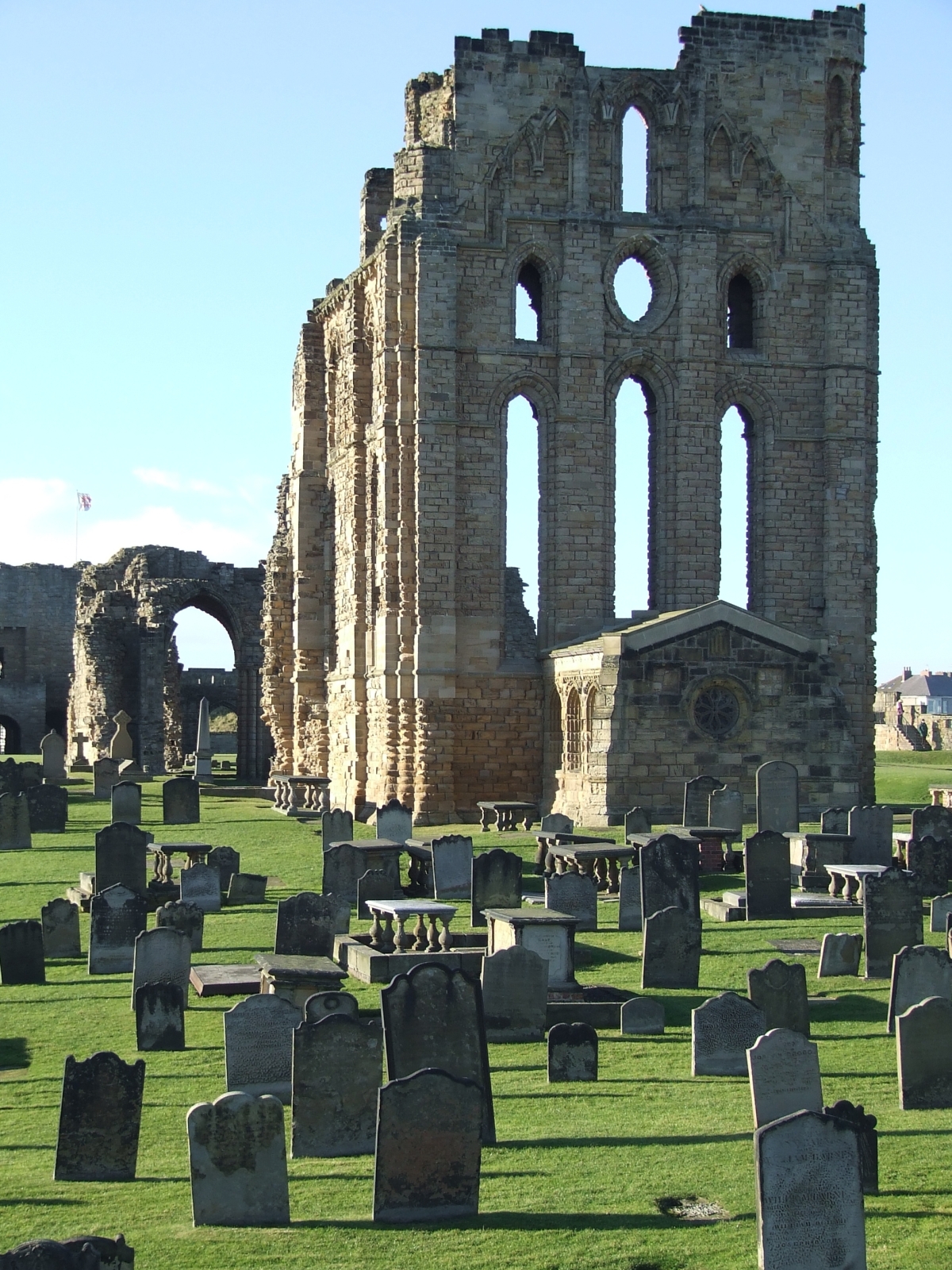
During my forays into the north for conferences at the University of Sunderland I twice visited Tynemouth – just half an hour on the bus (the N56 from Roker, as I recall) up the coast, then the passenger ferry across the Tyne and a walk of a few kilometres around some very picturesque areas. I’ll come back to this a time or two for the vistas of the estuary by evening or a look at other attractions, but this time I’d like to touch down on the historic north headland, a high promontory guarding access to the river. No wonder the Normans built a castle there.

These photos were taken on my 2010 trip. I had pressure-related problems with my right ear while flying and spent the entire trip very ill, I twice visited doctors, once a free clinic in London, the other a local surgery in Whitby, arranged by the boarding house I was staying at. I slogged through the trip and was not well for months, but I certainly gathered some photographs while I was there, four flashcards worth.


November is a very changeable month in the UK, the last sunny days presaging the coming of snow in some years, at other times it’s really just rain. In 2010 the sun was shining through the wind was chill, and the pictures benefited from the light.

After leaving the ferry one walks east on the river bank through picturesque old sea-village areas, quaint pubs that drip history, past the memorial to Admiral Collingwood – more about that in another post – until coming to the headland. The ruins are not very impressive from a distance but up close they have much to offer, and are administered by British Heritage, whose red and white flag flies over the castles they preserve.


According to both history and legend, three kings are buried somewhere on that headland, including Malcolm III of Scotland. To walk that ground is to remind oneself of the depth of antiquity surrounding it – that people have looked out to sea from that rock since time immemorial, Celt, Saxon, Dane and Norman alike. Thousands of years of continuity lie beneath one’s feet, and it is with a certain reverence one views the salt-eroded stone. Truly, the sea wind does amazing things to building stone, chemically altering it as well as abrading it with gale-driven particles, so what was a fine-built structure seven, eight centuries ago is now a bizarre abstraction, the stone reduced to organic-seeming blobs. There are headstones reduced to this state in the churchyard on the cliffs of Whitby.


The original fortification was a wooden structure built by Duke William’s invaders (though I find it likely there were earlier structures on the site), while the extant ruins are of the extensive rebuilding that occurred in the centuries following. Tynemouth Priory also occupies the headland, protected by the castle from the landward side, and again not much survives. It would have suffered during Henry VIII’s crusade of 1539, known historically as “the dissolution of the monasteries,” when the church was stripped of much of its wealth, power and influence, and so many magnificent ecclesiastical buildings fell rapidly into disrepair and eventually ruin. Only a single internal chamber remains, the “chantry,” complete with stained glass windows, and this was used in later centuries as a magazine to keep gunpowder dry.


The military heritage of the headland is everywhere – not merely the medieval fortress but the guns that guarded the river mouth in much later times. A canon of 1859svintage is preserved in a firing embrasure on the north side, but the real link with past turmoil is the battery of light model 1893 naval guns in their concrete and steel emplacements which look out to sea as a historic exhibit. These guns were manned in the First World War by the Tynemouth Volunteer Artillery, though the closest the German High Seas Fleet came to Tynemouth was Hartlepool, about twenty miles south, in the early morning of December 16th, 1914.


I stood alone on that headland, looking at the autumn afternoon sea as ferries came and went on their routes to Scandinavia, and imagined how it must have been for the gunners on that bitter night, seeing the flashes to the south as Hartlepool took over a thousand German shells. My late grandmother, aged four, was in that town at the time, if I remember my family history aright. That night Whitby was also hit, and its famous abbey was damaged in the process. So in Tynemouth the gunners must have shivered in their greatcoats and peered into the darkness, nerves on edge and strung out for a sighting. Not that their already-antiquated guns would have been of any effect had the German actually shown up, but the defiant gesture would certainly have been made – and perhaps Tynemouth Castle and Priory would have also come off worst against the poorly-directed gunnery of the pre-electronic age.


One other aspect of local lore about the headland must be mentioned, the ghost of the Viking. Actually a Dane, a warrior named Olaf was left for dead after a 9th century raid but was cared for by the monks. In time he took orders and joined them, but many years later during another raid, he saw his brother killed, and died praying for his lost kin. Locals know him as the Black Monk, and his spectre, so the story goes, has haunted that headland for a thousand years, watching the horizon for the longships to return.


English Heritage has an information office and giftshop in the castle, and one can buy a day ticket to wander the headland and view everything from the graveyard of the priory to the monks’ latrine pits, walk the remaining walls of the fortification and wonder where those kings lie. If you have a feel for history, a sense of the gulf of human experience that has flowed by, this is an excellent spot to visit, and you can grab a good meal in the high street opposite the entry of the castle – try the Turk’s Head pub, I can vouch for their fish and chips!


Some useful links for further reading:


Mike Adamson


That's a stone pillar in the mid-ground, not a modern waste bin!


Late afternoon light, as I was leaving -- it would be full dark before I was back down the coast in Roker.


Wednesday, January 29, 2014

Meningie - Wellington - Strathalbyn again ... almost home

With the weather changing, it was time to leave the mesmerizing world of the Coorong, headed --
-- into the dairy country around Meningie, where ... ye gods! The UFOs have landed! No, it's just water tanks,
crowned with quite an array of microwave relay aerials. 
Hang a right: we'll be circumnavigating Lake Alexandrina on the way home...
"No Diving," says the sign ... while diving would be a pretty neat trick off Meningie's old jetty -- which ended
long before it reached any water, in 2009! This is Lake Albert, which connects with Lake Alexandrina" We're used to
seeing the lakes from the Milang Side, of course.
Meningie is a popular destination in the region -- a much bigger town than Milang. But we prefer
the peace and quiet of the Milang area.
As you round the lake and approach the Wellington Ferry from the east side, one thing you can count on
is that the weather will be changeable. This shot, and the next, are actually borrowed from our 2011 trip to
Mount Gambier, but they illustrate this point so perfectly, why not borrow them?
Change in the weather (in 2011), waiting for the Wellington Ferry to come back across...
...and here's the exact same place in 2009. Get out of the car, stretch the legs while waiting for the ferry...
A long, long zoom shot of colonial ruins which stand abandoned not far from the river. The region is
full of history drowsing side by side with technology.
There goes the ferry on its way to Wellington. We just missed it. Ten minutes later --
Here it comes, headed for Tailem Bend. Time to get back in the car -- they don't take long to unload.
Halfway across, shooting out of the window -- and already hearing the ruckus! Like Strathalbyn, Wellington
is the home to huge flocks of little corellas ... and when they mill around, they shriek as only wild parrots can.
Little corellas are cousins to sulphur crested cockatoos -- both are common in South Australia.
Invasion of the little corellas! They were everywhere at Wellington on this trip in 2009.
...the trees are full of them, and every ten minutes they'll take off, swirl around in a great cloud,
shriek for the sheer fun of it, and then settle right back down again.
The road back to Stathalbyn takes you through miles and miles of agriculture.
And here we are back at Strathalbyn, where we began --
Ducks graze the parklands, while the Angas River bridge heads across to the bandstand and, beyond, the church.
Wall art ... actually, it's the public rest room beside the park, and -- never miss the chance to
decorate a wall, right?
Detail from the wall art at Strathalbyn ...
-- the work is astonishing, and so beautiful --
-- an unexpected pleasure in the evening light, just before we headed for home.
Evening light o the towers of St. Andrew's church. And now ... time to head home for dinner: we'll
be there in an hour or so.
From the Coorong through to Meningie, all you can do is put your foot down hard, let the Princess Highway zip past at the speed limit, because there's not much there (though it's not as desolate as the area between Milang and Lanhorne Creek, which might as easily be a location on Mars). As you get closer to Lake Albert, on the shore of which Meningie sits, the air becomes, um, shall we say "redolent with the aroma of agriculture." In other words, it's dairy country, with about a thousand times more cows out to pasture than there are people in the region ... your nose will certainly confirm this statistic!

 Meningie itself is a popular holiday spot for folks from far afield; it's quite a large, busy town, though we much prefer the depthless peace and quiet of the Milang-Clayton-Finiss region on the "home side" of Lake Alexandrina. In 2009 the water levels were low (too little rain -- which is becoming way too predictable in South Australia of late; troublingly predictable), and we could only chuckle at the sign stipulating "No Diving!" from a jetty that didn't get anywhere near the lake. Interestingly, "Meningie" is an Australian Aborigine word meaning "mud hole." One imagines the climate used to be a whole lot wetter in the past! (The map to left is a screencap from Google -- see it full sized, if you want to get a grasp on the geography -- it's quite readable.)

Then ... Wellington Ferry again, and the run through to Strathalbyn, where we stopped for a stretch of legs, snack and tea (or coffee, if you prefer; the picnic basket is always well stocked), before we headed home. Wellington had been invaded by little corellas in 2009, very likely the same flocks as gather in Strathalbyn too. They're great to watch, not so great to listen to, since they're LOUD!!

With evening light settling and dinner in mind, we headed straight for home ... which, on the above map, and at the time, was approximated by the "Marion" you see due south of Adelaide. (We've moved since then.)  And "it's a wrap!" That was it for another road trip. Now, where to next?!

Related Posts Plugin for WordPress, Blogger...