Showing posts with label ruins. Show all posts

Saturday, February 2, 2019

The Embattled Headland: Tynemouth Castle & Priory


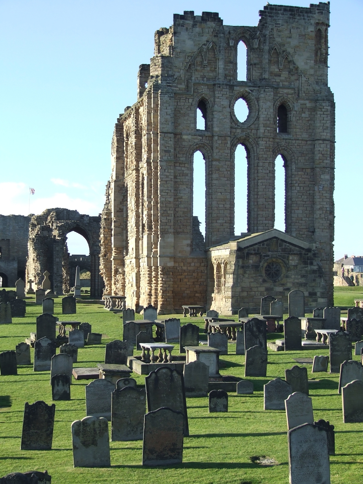
During my forays into the north for conferences at the University of Sunderland I twice visited Tynemouth – just half an hour on the bus (the N56 from Roker, as I recall) up the coast, then the passenger ferry across the Tyne and a walk of a few kilometres around some very picturesque areas. I’ll come back to this a time or two for the vistas of the estuary by evening or a look at other attractions, but this time I’d like to touch down on the historic north headland, a high promontory guarding access to the river. No wonder the Normans built a castle there.

These photos were taken on my 2010 trip. I had pressure-related problems with my right ear while flying and spent the entire trip very ill, I twice visited doctors, once a free clinic in London, the other a local surgery in Whitby, arranged by the boarding house I was staying at. I slogged through the trip and was not well for months, but I certainly gathered some photographs while I was there, four flashcards worth.


November is a very changeable month in the UK, the last sunny days presaging the coming of snow in some years, at other times it’s really just rain. In 2010 the sun was shining through the wind was chill, and the pictures benefited from the light.

After leaving the ferry one walks east on the river bank through picturesque old sea-village areas, quaint pubs that drip history, past the memorial to Admiral Collingwood – more about that in another post – until coming to the headland. The ruins are not very impressive from a distance but up close they have much to offer, and are administered by British Heritage, whose red and white flag flies over the castles they preserve.


According to both history and legend, three kings are buried somewhere on that headland, including Malcolm III of Scotland. To walk that ground is to remind oneself of the depth of antiquity surrounding it – that people have looked out to sea from that rock since time immemorial, Celt, Saxon, Dane and Norman alike. Thousands of years of continuity lie beneath one’s feet, and it is with a certain reverence one views the salt-eroded stone. Truly, the sea wind does amazing things to building stone, chemically altering it as well as abrading it with gale-driven particles, so what was a fine-built structure seven, eight centuries ago is now a bizarre abstraction, the stone reduced to organic-seeming blobs. There are headstones reduced to this state in the churchyard on the cliffs of Whitby.


The original fortification was a wooden structure built by Duke William’s invaders (though I find it likely there were earlier structures on the site), while the extant ruins are of the extensive rebuilding that occurred in the centuries following. Tynemouth Priory also occupies the headland, protected by the castle from the landward side, and again not much survives. It would have suffered during Henry VIII’s crusade of 1539, known historically as “the dissolution of the monasteries,” when the church was stripped of much of its wealth, power and influence, and so many magnificent ecclesiastical buildings fell rapidly into disrepair and eventually ruin. Only a single internal chamber remains, the “chantry,” complete with stained glass windows, and this was used in later centuries as a magazine to keep gunpowder dry.


The military heritage of the headland is everywhere – not merely the medieval fortress but the guns that guarded the river mouth in much later times. A canon of 1859svintage is preserved in a firing embrasure on the north side, but the real link with past turmoil is the battery of light model 1893 naval guns in their concrete and steel emplacements which look out to sea as a historic exhibit. These guns were manned in the First World War by the Tynemouth Volunteer Artillery, though the closest the German High Seas Fleet came to Tynemouth was Hartlepool, about twenty miles south, in the early morning of December 16th, 1914.


I stood alone on that headland, looking at the autumn afternoon sea as ferries came and went on their routes to Scandinavia, and imagined how it must have been for the gunners on that bitter night, seeing the flashes to the south as Hartlepool took over a thousand German shells. My late grandmother, aged four, was in that town at the time, if I remember my family history aright. That night Whitby was also hit, and its famous abbey was damaged in the process. So in Tynemouth the gunners must have shivered in their greatcoats and peered into the darkness, nerves on edge and strung out for a sighting. Not that their already-antiquated guns would have been of any effect had the German actually shown up, but the defiant gesture would certainly have been made – and perhaps Tynemouth Castle and Priory would have also come off worst against the poorly-directed gunnery of the pre-electronic age.


One other aspect of local lore about the headland must be mentioned, the ghost of the Viking. Actually a Dane, a warrior named Olaf was left for dead after a 9th century raid but was cared for by the monks. In time he took orders and joined them, but many years later during another raid, he saw his brother killed, and died praying for his lost kin. Locals know him as the Black Monk, and his spectre, so the story goes, has haunted that headland for a thousand years, watching the horizon for the longships to return.


English Heritage has an information office and giftshop in the castle, and one can buy a day ticket to wander the headland and view everything from the graveyard of the priory to the monks’ latrine pits, walk the remaining walls of the fortification and wonder where those kings lie. If you have a feel for history, a sense of the gulf of human experience that has flowed by, this is an excellent spot to visit, and you can grab a good meal in the high street opposite the entry of the castle – try the Turk’s Head pub, I can vouch for their fish and chips!


Some useful links for further reading:


Mike Adamson


That's a stone pillar in the mid-ground, not a modern waste bin!


Late afternoon light, as I was leaving -- it would be full dark before I was back down the coast in Roker.


Saturday, April 27, 2013

Farewell to Warrawong, Part 2: hike the whole site in pictures


In the second part of our tribute, "A Farewell to Warrawong," we've put together a hike around the whole sanctuary, choosing images from several visits over several years. (See Part One here.)

The images are displayed smaller on this page than usual, because there's a lot of them, but if you'd care to see them at larger size, they're almost all uploaded at 1200 pixels wide. (Sorry about the download lag as you load up this page. There is no way, seriously, to do justice to the concept of a "Warrawong walk-around" without a lot of pictures. Bear with us -- we believe you'll enjoy this post; and if you have fond memories of Warrawong, and miss it, you might enjoy this bit of nostalgia even more.)

The map, at left, is a scan from the last brochure produced by the sanctuary. The Bilby Cafe is at bottom left, and the hike takes us clockwise around the whole property, via the grass lands, the swamp, the lake, the rainforest, tall forest, the ruin (marked with the red icon) and the scrub lands.

So, saddle up your hiking shoes, and here we go:

Enter Warrawong under the arch, from the car park (ie., parking lot)...

Into the Bilby Cafe, and on through the big glass doors to the deck...

Outside the cafe is an "artificial" pond which itself is a habitat for this...

Murray River turtle.
Before you leave the deck, take a moment to actually read the information boards that tell the story of Warrawong, and give you a little info about the grass lands area you're about to hike.


The deck passes over that artificial pond, those turtles...

Follow the deck, pass under the arch...

Down the steps: see the grass lands immediately below.

"Raindrops keep falling on my lens..." This visit, it rained!

Kangaroos at the Warrawong grass lands, sunny day...

Kangaroos at their ease, soaking up some rays...

A roo lives the good life at Warrawong.

As you leave the grass lands, you're heading down to the lowest point on the property -- the swamp. It's planted in with reeds and water lilies ... you'd expect to see swamp hens, all manner of ducks, black swans, and this is the only place on mainland south australia where platypus nest!


Heading from the grass lands down to the swamp...

Look back -- look up -- at the Bilby Cafe and reception center.

Heading for the lowest point on the property...

A chain of ponds, paradise for ducks and frogs...

...with the big lake at the bottom of the hill.

The "swamp" is actually rather picturesque...

...reeds, lilly pads, wild ducks and black swans...
Take a moment to read the information board. Platypus, too!
From the wetlands, you'll follow the trails and boardwalks to your left. As you leave behind the swamp, you're headed for the wooded lake, known as Black Lake. It's a riot of flowering native shrubs, in season, and you can see geese, koalas, bandicoots, as well as some Very Tall Trees!

Heading down to the lake...

Black Lake, from the boardwalk.

A habitat for waterbirds, amphibians and turtles...

Cape Barren geese at Warrawong.

Black Lake in springtime ... ker-chooo!

Black Lake, Warrawong at its loveliest...

Late spring in native Australian bushland...

The tall trees region. Watch out for koalas.


Passing on from the tall trees region, you head left and down again. In fact, you're following a board walk into a gully. On a hot day, the air temperature drops ... it's also humid, and you pick up the scents not of a eucalypt forest, but of a rainforest. The bottom of the gully is stunningly humid, with carpets of moss; the boardwalk is lined by tree ferns, in the top of which sleep Aussie possums...


...and in this last image, you can see that you've actually begun to climb back up, out of the rainforest gully, and back into the Australian scrub land that's common to regions with lesser rainfall. You're at the lowest point in Warrawong as you begin the climb, and it's a little test of the legs. You don't have to be an athlete, but a few muscles definitely help. Also, this is one of the areas that's inaccessible to wheelchairs, which was always a pity. Climbing out, you're rewarded at the top:


It's marked on the Warrawong map as "the ruin..."


Cape Barren geese, dining on dandelion flowers, by the ruin...


...and from the ruin, you see the trail winding off into what's called the scrub land, on the map. The scrub is very close to the kind of native bushland you see in the national parks, and at places like Jupiter Creek. Before European settlement, the clearing of the Adelaide Plains area (for the city), and the deforestation of vast swathes of the hills (for gold mining, among other things), such forest would have been virtually coast to coast -- note that old growth, or original growth, would be much denser than the scrub you see here:


On the scrub land trail, you'd often see wild kangaroos and bandicoots ... real wild kangaroos, as clearly distinct from the laid-back, drowsy, human-friendly critters in the grass lands. Up here, the roos are flighty, nervous, ready to race off into the woods at the hint of human presence --


...and as you leave behind the scrub land, you find yourself back at the "top" of Warawong Sanctuary, on a short path leading past the cabins and right back to the Bilby Cafe:

Follow the trail right back to the Bilby Cafe. Tea, anyone --?

For years, Warrawong Sanctuary was one of our favorite places in the Adelaide Hills. We were so sad to learn that it was closing (see the reasons in the first part of this two-part feature), and ... here is our "Farewell to Warrawong," which we'll probably come back to often as visitors to our own blog, to jog the memory. The images were captured in all seasons, in all weathers, but there was one constant: Warrawong Sanctuary was beautiful, tranquil, and unique.


Related Posts Plugin for WordPress, Blogger...