All these images are from my phone. This trip took place over three months ago, and due to one thing and another I still haven't even started to go through the camera archives yet, though it was simple enough to go through the phone pics and chronicle the trip. The truth is, for 80% of the trip, the weather was horrible. I took about a quarter as many photos as I'd imagined I would, and in rotten-light conditions, the phone does a job almost as good as the camera. So -- let's run with the phone pictures, yes?
The trip all started with a stack of baggage ... you'd have thought we were off to Antarctica for six months! No ... "just" the Grampians for five days:
Getting out early, you cross the Murray River at Wellington...
...and you aim for breakfast in Keith, on the Duke's Highway, only to discover that it's actually lunch by the time you get there! So --
-- the Henry + Rose Cafe, very nice, with good food. The weather was steadily going downhill as we headed east, though, but the sun still shone in patches, between broad cloud banks:
The state line is right there. Welcome to Victoria ... and slow down. The speed limit is lower, east of the border. So -- onward, through little towns and agricultural communities...
Above: canola fields near Kanvia. The Duke's Highway turns into the Western Highway at the border, but we always think of it as "east," not west! This time around, we left the main E-W highway at Nhill, turning south to take a look at the Little Desert National Park --
-- which, to South Aussie eyes doesn't actually look like a desert at all. Maybe it's seasonal? So much of SA looks like this pretty much all the time, one is reluctant to call it a desert. Then, it's not so far from there to the beautiful Wartook Valley. And whaddaya know --
Above: A rainbow over Wartook Valley. Now, that bodes well. You see the Grampians low down on the horizon from the valley. While Dave stretched the legs I played with the phone, and managed to get a selfie where I didn't look like Marley's Ghost:
There you are -- that proves I was on the trip! Dave did take a few shots of me here and there, and I managed to get several of him. He likes to play around, so pictures of him are often something of a laugh riot. And why not?
You don't have time to tarry long on breaks ... not if you want to get there on the same day! Apparently, you can drive Adelaide to Halls Gap in six hours, but we usually take nine or ten over it. Then again, we always get there safely, without being totally wasted. So.
When you head into the National Park, all at once the road turns UP, and twists and twines constantly for about the next 30k. Glorious views from the roadside as evening settles --
Above: Lake Wartook, the reservoir, seen from Reid's Lookout. It was actually quite dark by now; enhancement on the image brightens it up. It had also been raining recently...
Halls Gap was quite damp as well as quite dark. (And you can see what I mean about the weather. When it didn't actually rain, the sky was deeply overcast. Mostly, I put away the camera and just sat back for the trip!)
Time to check in, unload, get dinner, sleep. We were booked into the Halls Gap Log Cabins:
Wonderful ... all the comforts of home. Each cabin is like a small house, with every amenity imaginable, with the exception of a washer and dryer. And who wants to do laundry on trip?!
Above: Rainy, misty and COLD in the morning. Luckily, we'd got brilliant pictures back in March, because the images from Cathedral Rock (seen here off the Mount William road) are gray and soft. Rain was threatening, and the wind cut like a knife. The cold abated a little by the time we arrived at Sundial Lookout and took the Lake View Lookout trail:
Still not warm, but not so windy, and the mist was clearing. I crossed my fingers, hoping to get good photos as the say went on. So, leaving Sundial, we headed to Silver Band Falls, which is a good hike down into a gorge to reach this:
Not a heck of a lot of water in it, when you consider that this is the end of the rainy season, and it should be running hard and fast. Hmm. So -- back on the road. Below, top: Mount Zero Road. Center: Canola fields in Wartook Valley, looking toward the Grampians. Bottom: Sunset from Reid Lookout. It wasn't spectacular at all ... too much heavy weather.
Next morning we spent a couple of hours at the Brambuk Cultural Centre, which is a chastening experience. One is rocked back by the history of this country's indigenous people. I find it astonishing that any of them survived at all, and ... so sad. One could wish for a time machine, go back and change it, find the people responsible, and stop them ever arriving in Australia...
From Brambuk, we headed outward to explore. Lunch found us on the freezing, wind-swept heights of One Tree Hill above the town of Ararat. Yes, we visited Mount Ararat earlier; I photographed that with the cameras, not this phone. It's not what you'd call ... spectacular, but we did it! However, the views from the top of One Tree were amazing:
And from Ararat we headed back around the Grampians in a great circle. The area south of Ararat is big on canola, and the afternoon sun shone, making for some stunning photos at last:
By the time we were south of the Grampians and about to head back up the west side, toward Wartook, we'd run back into gray weather. This is Mt. Sturgeon, near Dunkeld ... the Grampians end (or begin!) right here, on the south tip of the range.
Dunkeld to Cavendish offered some amazing skies. Enhancement on the image here brightens it up, because we're actually almost along to evening now. And --
Yes, Virginia, there is actually a Bunyip Hotel! In Cavendish, in the evening light, before we headed north again up the west side of the mountains...
We'd been hoping to get some great shots of the Grampians in the evening light, but the skies were too heavy, and sunset "didn't happen." Well, it did, for eight seconds, with a few shades of pink. But the drive was lovely, the scenery starkly beautiful.
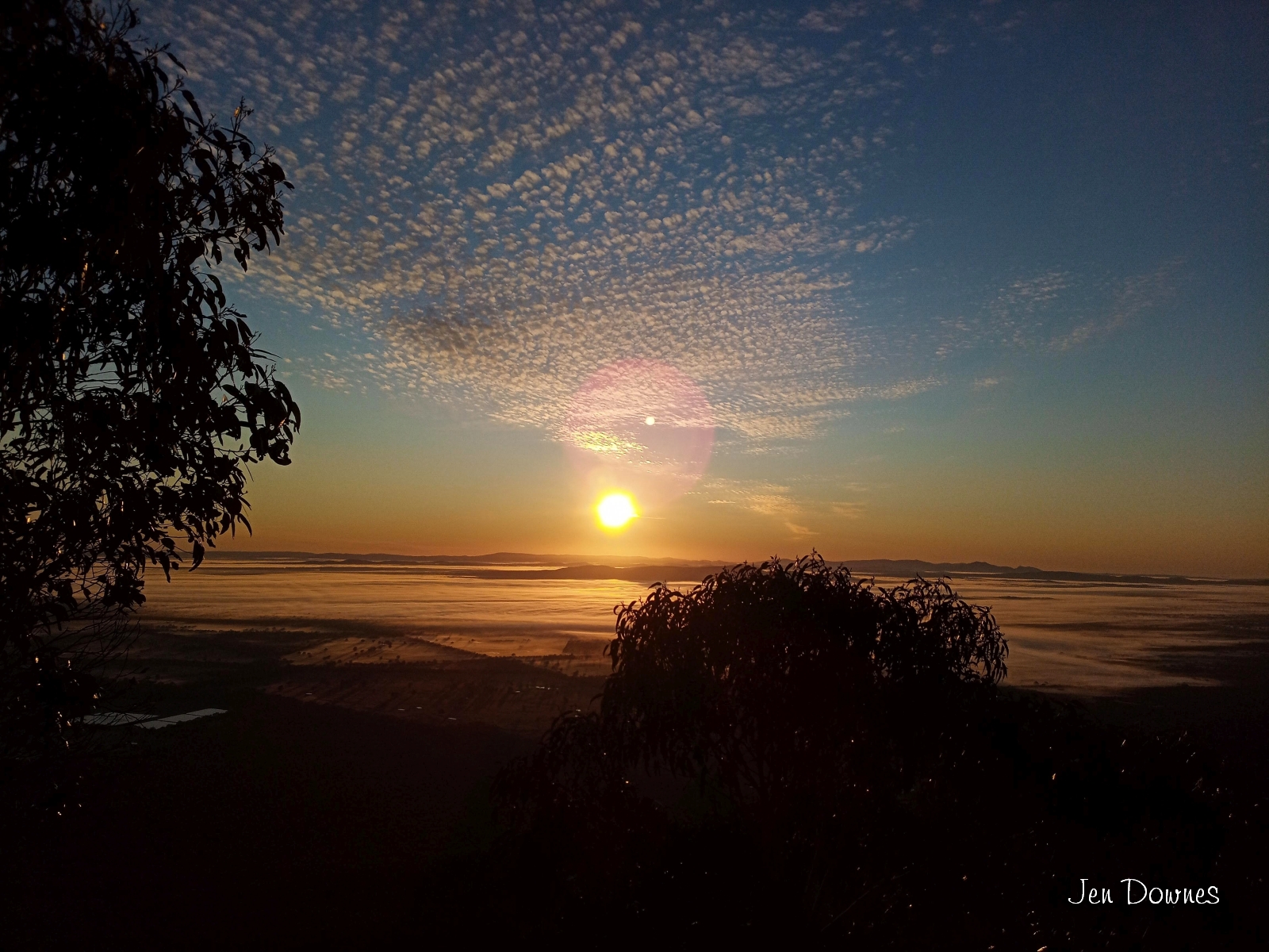
At last! Like magic, the sky cleared for our last day in Halls Gap. We were at Boroka Lookout in the very early morning. Glorious! Then it was off to Mackenzie Falls, where we spent half the time photographing wildflowers, which are at their best at this time of year. Here's a wild orchid --
-- and below, the actual falls, seen from one of the high lookouts. Again, not much water in evidence, which doesn't bode well for summer, I think. We knew of one more waterfall, Beehive Falls, off thr Roses Gap road, so while the sun shone we thought we'd give it a go...
Perfect weather, a wonderful hike, stunning rock formations, wildflowers in profusion ... but the falls was a mere trickle. Nothing there. But the hike itself was a huge pleasure. Good thing, because this was a wrap on our last day in the region! Time to pack and clean out the fridge in the morning.
We'd decided to come home on the Princes Highway, via Naracoorte, and by the time we reached Mount Arapiles the weather was awful. You can drive to the top of Arapile, and the view --
-- is fantastic. But I barely managed to get a shot of the mountain itself, because the light levels were so low. From Arapiles, we headed for the Princes Highway and turned west...
Stretch the legs at Sundial Park in Kingston SE. The road sign, leaving town, tells all. Adelaide is still almost 300k away, via Salt Creek, Meningie, Tailem Bend, Wellington (the ferry), Strathalbyn, and so forth. Below: top: leaving Kingston SE. Center: You're looking at Salt Creek. All of it. Bottom: Meningie. Not stopping -- it's getting late, and there's still a looong way to go:
Over the river, head through Langhorne and turn northwards for Strathalbyn. Mother Nature had one last treat for us:
Sunset, somewhere on the road home, I actually forget where! Somewhere between Langhorne and Strathalbyn?? From here, you'll be home in about seventy-five minutes. Phew! That's another one to cross off the bucket-list! This time, I actually drove for a while, too. Now, where to next ...?!
Showing posts with label Kingston SE. Show all posts
Tuesday, February 4, 2020
Return to the Grampians
Labels:
Aboriginal sites,
cafe,
Cavendish,
driving,
Dunkeld,
ferry,
flowers,
Grampians,
Halls Gap,
hotel,
Kingston SE,
Meningie,
mountains,
Mt. Arapiles,
national park,
Princess Highway,
rainbow,
Salt Creek,
sunset,
Victoria
Friday, January 31, 2014
All posts in order: Naracoorte 2009, done and dusted
![]() |
| Alexandra Cave, Naracoote |
Naracoorte 2009: Preview
...where we're headed, what's on the agenda, from wetlands to wet caves and a dry lagoon, limestone caverns, Larry the Biiig Lobster, the Coorong, and a lot more.
|
| St. Andrew's, Strathalbyn |
Strathalbyn and points east
Cloudy skies in the morning ... Wellington Ferry ... Tailem Bend for lunch, and on into grain country -- Coomandook, Coonaplyn and Culbara.
![]() |
| Land Rover on a Pole: Keith |
Keith - Padthaway - Naracoorte
The Land Rover on a pole (the real deal!), the wind harp, and the swimming lake ... it's a long haul from Tailem Bend to Naracoorte!
![]() |
| Wonambi Fossil Centre |
The Wonambi Fossil Centre and the Alexandra Cave
Breakfast by the lake ... wrestling skeletons at Wonambi ... and let's get underground on the Limestone Coast!
![]() |
| Megafauna! |
Megafauna! And ... where's the water? Bool Lagoon in 2009
Extinct creatures are brought to life, we step back in time in the Wet Cave, and then the bird sactuary of Bool Lagoon turns out to be ... well, in a word...
![]() |
| The Big Lobster, Kingston S.E. |
Fossils and Ibis and Lobsters -- oh, my!
The Victoria Fossil Cave ... Thylacaleo in person ... ibis in profusion, horses on vacation, the world's oddest sundial, the lighthouse that came ashore, and -- Larry the Lobster himself! In other words, Naracoorte to Kingston S.E., in time for lunch.
![]() |
| The Coorong, near Salt Creek |
The Coorong at last -- and the sun shone!
The Princess Highway ... Salt Creek ... a lot of black swans and a little bit of history ... and the Coorong is so pretty in the sunshine. Perfect!
![]() |
| Murray River, Wellington Ferry |
Meningie - Wellington - Strathalbyn: almost home
Leaving the Coorong, heading home via the dairy country and Meningie on Lake Albert. Around the Lakes District to Wellington, which has been invaded by parrots; then evening light over Strathalbyn...
Sunday, January 26, 2014
Fossils and ibis and lobsters ... oh, my!
.![]() |
| Limestone imitates colossal fantasy wedding cakes at the Victoria Fossil Cave |
![]() |
| Stop by the Wonambi Fossil Centre first for tickets to the guided tour. And note the correct spelling ... not of 'Wonambi,' but of 'Centre.' |
![]() |
| The area was recognized and World Heritage listed 20 years ago... |
![]() |
| ...and here's why! 'Spectacular' is an understatement. Want more? Scroll down: |
![]() |
| Looking between the jaws of the sleeping dragon. Check out those teeth! |
![]() |
| This is not Thylacoleo carnifex -- in fact, it's Simosthenurus occidentalis. |
![]() |
| This shaft was drilled in the early days after the caverns were discovered ... they were pouring concrete to make the paths and walkways, in an era before the word "preservation" was understood! |
![]() |
| Checking out of the William McIntosh Motor Lodge the net morning. We'd be home for dinner, but... lots to do and see first! (That's the trusty old Camira, not Lola, of course ... 2009. Right.) |
![]() |
| This is what we'd hoped for at Bool Lagoon! This is just a flooded hollow off one side of the road out of Naracoorte... |
![]() |
| Imagine how Bool Lagoon would be, when it's, uh, wet! Ibis Cape Barren geese, mallards, and scores of swallows. |
![]() |
| The thriving metropolis of Lucindale ... we're headed for Kingston S.E. now. |
![]() |
| And as Tolkien said, the road goes ever on... |
![]() |
| ...through pastoral landscapes under a steadily lowering sky. Yes we're losing the weather. |
![]() |
| Kingston S.E. -- the bridge over the Maria Creek ... |
![]() |
| -- which features some wonderful artwork and sculpture, such as... |
![]() |
| -- seals, carved in a local stone -- not sure what kind. |
![]() |
| One of the most interesting things in Kingston S.E. is the Analemmatic Sundial. Say, what?! |
![]() |
| Seriously! It's a 'sundial of human involvement.' See this info board at full size -- it's perfectly readable here. |
![]() |
| Dave demonstrates how it works, and -- know what? It tells the right time, too! It's tickling 10:00am. |
![]() |
| Geographic sculpture and welcome swallows at the gas station -- |
![]() |
| Tiny, tiny birds that rarely sit still. You seem to see these guys everywhere in South Australia, except in town. |
![]() |
| The other landmark for which Kingston S.E. is famous ... it's hard to miss. |
![]() |
| The Big Lobster -- "Larry the Lobster," in fact! And for scale, here's Dave sitting right under it. It's, uh, big. |
![]() |
| Cape Jaffa Historic Lighthouse was moved to Kingston S.E. from Margaret Brock Reef, 15km SW of here -- |
![]() |
| The National Trust info board tells all. |
![]() |
| Horses out for a day at the beach, just an hour's drive over from Naracoorte. |
![]() |
| The hiking/biking trail through the salt bush, just above the beach. Watch out for snakes! |
![]() |
| The beach at Kingston S.E. ... inviting, but we didn't stop for long, because -- |
![]() |
| We're off to the Coorong now, headed back to Adelaide on the Princess Highway. |
One of the most dramatic of the creatures unearthed in these caves is Thylacoleo carnifex, a predator on top of the food chain in its day; and wouldn't you know it, Jade couldn't get a good picture of the fantastic skeleton on display in the depths of the Victoria Cave: the light was very low, and with the guided tour group, she could never jockey into a good position for long enough to get a shot! So --
![]() |
| The artist's reconstruction of Thylacoleo carnifex, borrowed from the Australian Museum website, and used here within their copyright guidelines. © Australian Museum |
Also -- from Wikimedia comes this great shot of the skeleton ... in fact, it's the shot Jade couldn't get on site, on the day:
![]() |
| From Wikimedia. Credit: Karora ... License: Public Domain. |
![]() |
| Picture by Dr. Mike Adamson, who worked on the reconstruction in 2011. |
![]() |
| Picture by Dr. Mike Adamson; 2011. |
"This was the second Thylacoleo which was built, taking less than three weeks, and it was finished and mounted just three hours before the Investigator Lecture." -- Dr. Mike Adamson
It was getting late by the time we returned to the the William McIntosh Motor Lodge ... dinner and a good night's sleep were in order, because we were checking out early the next morning. We were headed home, but a lot of miles and some great places were ahead of us. First destination: Kingston S.E.
The "S.E." was added to differentiate this coastal town from the Kingston on the Murray River. It's a very nice town, strung out along a lovely beach. The sky was lowering ... we were losing the weather, running back into clouds and possible rain, just as we'd set out into, days before. First: go-juice in the car. Then, check out the "sundial of human involvement" ... hey, it works! See the pictures, above, in which Dave demonstrates.
And then ... The Big Lobster. Larry the Lobster. And the name doesn't deceive: it's huge. It sits right at the end (or beginning) of the Princess Highway -- in fact, the physical address is 1, Princess Highway. Alas, in recent years Larry has been allowed to fall into disrepair, and if you look at the reviews of the cafe for which the lobster is the draw-card, well ... turns out, it's not actually somewhere to stop if you're hungry and/or in a hurry. Folks say the food is just okay but the service is slow and the prices are high. Hmm. Good thing we'd packed an awesome picnic basket!
So we headed down to the foreshore for lunch, using one of the gazebo-style structures because quite a wind was whipping across the beach. All the way from Naracoorte, we'd been playing tag with a horse transporter. First they'd stop, then we'd stop, so we were always in touch -- and in fact we were headed to the same spot. A farm family from one of the properties right by Naracoorte were taking their horses for a day at the beach. They recognized the Holden Camira ... she was easy to spot, and identify; Camiras had a problem with their paintwork. Holden used something called "Ocean Mist Green," and it literally fell off, so Jade's dear old Camira was "patchy," to use a generous term. But she also went like a rocket, and we kept her probably longer than we should have, before Lola joined the clan. So the farm family recognized us, and we recognized them -- we got to talking, and it made for lovely interlude.
Suitably refueled, we checked out the Cape Jaffa Lighthouse. We'd wanted to climb it, but it was closed, locked up, on the day ... well, dang. Another time. And speaking of time -- we had to be moving, if we wanted to see something of the Coorong while the light, and the weather held. So --
Next time: Salt Creek, black swans, and the Coorong.
- If you enjoy the Bill Cosby version -- Dave covered this part of the trip in Fossils in them thar hills, plus Narracoorte to Lucindale, and The Journey Home: Kingston S.E.
Labels:
art,
beach,
Big Lobster,
birds,
bridge,
cafe,
Cape Barren geese,
car,
caves,
fossils,
horses,
Ibis,
Kingston SE,
lighthouse,
Limestone Coast,
snakes,
statues,
sundial,
wetlands,
Wonambi Fossil Centre
Subscribe to:
Posts (Atom)


